Item is a topographic map with ms. additions showing territories, former villages, and current villages of the Tsimshian, Nootka, Salish, Kwakiutl, Haida and Tlingit people in British Columbia and the northern United States. Base map: British Columbia / compiled and drawn by Geographic Division, Surveys and Mapping Branch, 1957; published by Lands and Forests, Victoria, 1958.
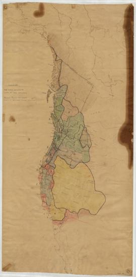
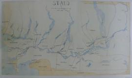
Item is a map that shows location and territorial boundaries of the Stalo and neighbouring Salish tribes in the last quarter of the 19th century. Includes river and place names. Encapsulated.
Items are published maps with ms. additions. Notations show the territories of the South Kwakiutl, Nootka and Coast Salish tribal groups; and some place names. Arrows drawn may represent the southward migration of the Comox, mentioned in Duff's lecture notes (box 11, file 3; box 8, file 32); and arrows and dates may indicate the annual movements for reef netting described in his lecture notes on the Coast Salish (box 7, file 25 and box 8, file 41). Notations are possibly in Duff's hand. Both sheets have been cut, possibly for presentation purposes. Encapsulated. Base maps cannot be identified.
Item is a map that shows Tsimshian territories, tribes, villages and sites, marked by arabic numbers. Includes Roman numerals indicating the territory of chiefs, by rank. Item appears to be a consolidation of information derived from the files of Marius Barbeau. Duff intended to produce a complete description of the social structure of Tsimshian tribes, and for that purpose mapped territories and village sites found in Barbeau's work. In English and Tsimshian. Photocopy available, Duff-CM-46. Duff refers to this project in a 1964 article (Anthropologica 1964:1, available in box 2, file 8) and in a progress report letter to Charles E. Borden, dated November 15, 1958 (available in Borden's papers, Box 51, file 49, U.B.C. Special Collections).
Item is a copied base map with ms. additions showing location of reserve areas. Notations in Duff's hand. Encapsulated. Base map: Southeast Vancouver Island base map, Duff-CM-22.
Item is a published topographic map with ms. additions showing the location and extent of Spallumacheen reserves. Marked "C. Saunders 1195682." Spelling of band name in notation differs from spelling on base map. Base map: 82L : Vernon, British Columbia, West of sixth meridian. -- 1st ed. / produced by the Army Survey Establishment, Mines and Technical Surveys, Ottawa, 1966.
Item is a published topographic map with ms. additions showing Vancouver area reserves. Notation on verso: "Pete Stabie, 1577717, Anthro 301." Base map: 92G : Vancouver, British Columbia. -- 1st ed. / produced by Surveys and Mapping Branch, Department of Mines and Technical Surveys, Ottawa, 1959.
Item is a published topographic map with ms. additions showing old and new reserves, and extensions to reserves. Includes affixed key titled "Hartley Bay Band," explaining numbered notations and indicating which reserves are not shown. Encapsulated. Base map: Sheet 103H and part of 103G : Douglas Channel, British Columbia.
Item is a published topographic map with ms. additions. Notations indicate limits of Kamloops band reserve #1, as announced by the reserve commission; comments on the nature of the reserve's terrain; notes on the extent of tribal land; and the location of reserves #2 and #3. Base map: Sheet 92 I/NE : Kamloops Lake, British Columbia, Kamloops Division of Yale land district. -- 2nd status ed. / compiled and produced by Geographic Division, Survey and Mapping Branch; Department of Lands, Forests and Water Resources, Victoria, B.C., 1968.
Item is a published topographic map with single ms. notation "#14" added at northern end of Moore Island. Base map : 103A : Laredo Sound, British Columbia. -- 1st ASE ed. / produced and printed by Surveys and Mapping Branch, Department of Mines and Technical Surveys, Ottawa, 1962.
Item is a published topographic map with ms. additions showing location and extent of Nanaimo band reserves. Base map: Sheet 92 G/4 West half: Nanaimo, British Columbia. -- 1st ed. / converted by the Army Survey Establishment, Department of Mines and Technical Surveys, Ottawa, 1955.
Item consists of two published maps, taped together, with ms. additions. Notations include broken lines indicating the boundaries of reserves of the Ohiaht tribe of the Nootka family, and numbering of the reserves located in Barkley Sound area of Vancouver Island. Title taken from notation, on verso: "Roslyn Ellison, Ohiaht Band Reserves D2." Base maps: Sheet 92 C/14 : Barkley Sound, British Columbia. -- 2nd ed. / published by Army Survey Establishment, Ottawa, 1956; Sheet 92 C/15 : Nitinat, British Columbia / revised and printed by Army Survey Establishment, Ottawa, 1955. Faded; tape yellowed and loosening.
Item is a published map showing territories of British Columbia native people, and numbered locations of regional and local tribes/bands. Verso: Illustration, text titled Native Indians : Distribution of Ethnic Groups - 1850, and key to location numbering. Inset: Local tribes and regional groups of Southwest British Columbia. Marked "Adapted from British Columbia Atlas of Resources (1956), Map no. 12." Used as base for Duff-CM-31. Item is published by British Columbia Natural Resources Conference, Map Production Division, 1956
Item is a copied base map with ms. additions showing Tlingit, Haida, Pentlatch and Bella Coola territories in eighteenth-century British Columbia. Notations in Duff's hand. Encapsulated. Base map: British Columbia base map, Duff-CM-23.
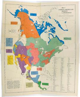
Item is a published map that shows the distribution and extent of 10 major North American language families and subdivisions. Faded and perforated.Published by Rand McNally for American Ethnological Society, 1966.
Item consists of outline map coloured to show eastward and westward influences on First Nations people in British Columbia and northwestern U.S. Stained. Encapsulated.
Item is a published map with ms. notations showing the Tlingit, Haida, Kwakiutl, Nootka, Kargani, Tsetsaut, Tahltan, Selani, Carrier, and Chilcotin. Annotations also show village names. Inset: Canada.