- 29-13-121-d
- Part
Parte deWilson Duff fonds
43 resultados con objetos digitales Muestra los resultados con objetos digitales
Parte deWilson Duff fonds
Parte deWilson Duff fonds
Parte deWilson Duff fonds
The War History of the Grizzly Bear People of the Kitselas People as Told by Chief Neas D. Hok
Parte deWilson Duff fonds
Parte deWilson Duff fonds

Parte deWilson Duff fonds
Parte deWilson Duff fonds
Parte deWilson Duff fonds
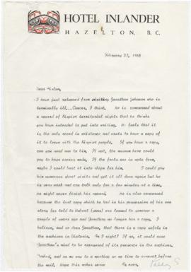
Wilson Duff interview with Jonathan Johnson at Kispiox
Parte deWilson Duff fonds
Item is an audio recording of an interview by Wilson Duff with Jonathan Johnson about the geography of the Gitxsan village of Kispiox and surrounding region. According to Tribal Boundaries in the Nass Watershed by Neil J. Stewart (MOA Reading Room, call number 12.7c GIT STE), Jonathan Johnson (1902-1968) of Kispiox was from the House of Xhliimlaxha and had knowledge of territories in the Nass watershed, including his father’s territory at Gwinhagiistxw. In interviews that took place on July 6 and 7, 1965, Duff gathered information about house territories in the Nass and Skeena watersheds to produce a map showing territories and numbered sites at Kispiox, see the Wilson Duff fonds at MOA, Box/File# Mc15, File# 10-B-21.
Parte deWilson Duff fonds
Parte deWilson Duff fonds
Anthropology 301 Kitwancool (301-1-9)
Parte deWilson Duff fonds
Parte deWilson Duff fonds
Parte deWilson Duff fonds
Parte deWilson Duff fonds
File consists of slides including: exhibits at Museum of Natural History, exhibits at Museum of History and Technology, July 1970, trip to Hazelton, Rupert, and other locations. Images include Kitwancool, Skeena and Kitwanga poles and Kispiox totems.
Parte deWilson Duff fonds
File consists of slides including: beach views, dances at Kitsilano showboat dances, Aiyansh, Kispiox, Kitwancool, Kitwanga, Ksan, Kits canoe races.
Parte deWilson Duff fonds
Item is a copied map that shows Kitwancool territories and villages, rivers and lakes referred to in "Territories of the Kitwancool" chapter in Histories, Territories, and Laws of the Kitwancool. Title taken from duplicate found in Histories. Encapsulated.
Parte deWilson Duff fonds
Item is a copied map that shows places, rivers and lakes of Kitwancool territory referred to in "History of the wars with the Tse-tsaut: How the village of Git-an-yow became Kitwancool" chapter in Histories, Territories, and Laws of the Kitwancool. Encapsulated.
Parte deWilson Duff fonds
Item is a copied map that shows territorial boundaries of the Kitwancool, territories of the Wolf and Frog clans, villages, and numbered sites. Inset: Location map. No legend provided for numbered sites. Based on "Territories of the Kitwancool" map included in Histories, Territories, and Laws of the Kitwancool, found in Duff's textual records, box 2, file 8. Mended with document repair tape in 1984. Encapsulated.
Parte deWilson Duff fonds