- 29-9-E-05
- File
- [19-]
Part of Wilson Duff fonds
93 results with digital objects Show results with digital objects
Part of Wilson Duff fonds
Northwest coast and plains influences
Part of Wilson Duff fonds
Item consists of outline map coloured to show eastward and westward influences on First Nations people in British Columbia and northwestern U.S. Stained. Encapsulated.
Part of Wilson Duff fonds
The World Is As Sharp As A Knife - Research
Part of Wilson Duff fonds
Part of Wilson Duff fonds
File consists of photographs of slate group. Images include carved slate sculpture of figures and animals. Artefacts pictured are presumed to be of Haida and/or Northwest Coast Indigenous design.
Part of Wilson Duff fonds
File consists of slides including: Bella Bella and Nootka poles, Juneau, Sitka, and Nanaimo poles, Port Hardy poles, Stanley Park poles and canoes, Mt. Currie housing, views of Rebecca Spit and Cape Mudge, aerial views, archaeological digs, sculpture, labrets, relief maps, Petroglyph Park, Skagat Attatl, George Clutesi Mungo poles, Provincial Museum at Victoria, Thunderbird Park. Note: Slides of Saanic have been added to section E-25.
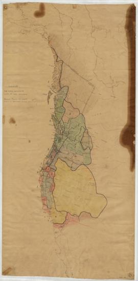
Central coast territories and places
Part of Wilson Duff fonds
Item is copy of portion of base map, with added notations showing Tlingit, Haida, Tsimshian, Haisla, Bella Coola, Heiltsuk, Owikena, Southern Kwakiutl, Nootka and Coast Salish territorial boundaries. Includes place names in abbreviated form. Base map: Central coast base map, Duff-CM-5. Sheet has loose leaf tabs attached. Encapsulated.
Part of Wilson Duff fonds
Item is a published topographic map with ms. additions. Notations indicate limits of Kamloops band reserve #1, as announced by the reserve commission; comments on the nature of the reserve's terrain; notes on the extent of tribal land; and the location of reserves #2 and #3.
Base map: Sheet 92 I/NE : Kamloops Lake, British Columbia, Kamloops Division of Yale land district. -- 2nd status ed. / compiled and produced by Geographic Division, Survey and Mapping Branch; Department of Lands, Forests and Water Resources, Victoria, B.C., 1968.
Part of Wilson Duff fonds
Part of Wilson Duff fonds
A heritage in decay - the totem art of the Haidas
Part of Wilson Duff fonds
Part of Wilson Duff fonds
Part of Wilson Duff fonds
Photocopies of items in File # 9-A-11
Part of Wilson Duff fonds
Part of Wilson Duff fonds
Map is marked "Resources Base." Base map used for Duff-CM-27, 28, and 30.
Part of Wilson Duff fonds
Part of Wilson Duff fonds
Part of Wilson Duff fonds
Games of the Haida Indians by Elain Featherstonhaugh
Part of Wilson Duff fonds
Anthropology 301 Tsimshian (301-1-6)
Part of Wilson Duff fonds