- 29-10-A-14
- File
- 1965-1976
Part of Wilson Duff fonds
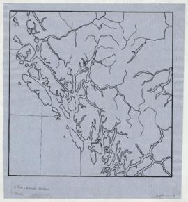
Used as base map for Duff-CM-39 and 40.
1492 results with digital objects Show results with digital objects
Part of Wilson Duff fonds
Used as base map for Duff-CM-39 and 40.
Part of Wilson Duff fonds
Map is marked "16 mi."
South Tsimshian, Kitimat, Haihais
Part of Wilson Duff fonds
Map is marked "16 mile."
South Tsimshian, Kitimat, Haihais
Part of Wilson Duff fonds
Map is marked "10 mi base."
Carrier and Chilcotin base map
Part of Wilson Duff fonds
Map is marked "27 mile base."
Bella Bella, Bella Coola, Owikeno
Part of Wilson Duff fonds
Map is marked "10 mi."
Part of Wilson Duff fonds
Map is marked "GG Salish" and "10 mi. base."
Part of Wilson Duff fonds
Map shows some discolouration and is marked "5 mile base." Base map used for Duff-CM-44.
Part of Wilson Duff fonds
Part of Wilson Duff fonds
Pacific coast native territories
Part of Wilson Duff fonds
Item is outline map coloured to show names and territorial boundaries of native people on the northwest coast of British Columbia and the northwestern United States.
Part of Wilson Duff fonds
Item is copy of printed map with ms. additions showing names and locations of various places along B.C.'s northwest coast. Encapsulated.
Part of Wilson Duff fonds
Item is printed map with ms. additions. Notations include shaded areas showing Tlingit, Haida and Nootka territories; boundary outlines of Tsimshian, Kwakiutl, and Coast Salish territories; Tsimshian, Kwakiutl and Coast Salish place names; and geographic locations. Perforated for loose leaf binder. Encapsulated.
Part of Wilson Duff fonds
Item is copied base map with added notations showing location and extent of Tsimshian, Kwakiutl, Nootka, Coast Salish and Bella Coola territories. Includes some place names. Base map: Cental coast base map, Duff-CM-5. Encapsulated.
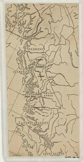
Central coast territories and places
Part of Wilson Duff fonds
Item is copy of portion of base map, with added notations showing Tlingit, Haida, Tsimshian, Haisla, Bella Coola, Heiltsuk, Owikena, Southern Kwakiutl, Nootka and Coast Salish territorial boundaries. Includes place names in abbreviated form. Base map: Central coast base map, Duff-CM-5. Sheet has loose leaf tabs attached. Encapsulated.
Part of Wilson Duff fonds
Item is base map with ms. additions showing the territorial boundaries of native people on British Columbia's central coast. Base map: Resource base, central coast.
Central coast territorial boundaries
Part of Wilson Duff fonds
Item is copy of portion of base map, with ms. additions. Notations show locations and boundaries of Northwest native people. Includes some place names. Base map: Central coast base map, Duff-CM-5.
Part of Wilson Duff fonds
Item is a copied map that shows territorial boundaries of Northwest coast native people. Added notations identify Tlingit, Tsimshian and Haida territories and clans.
Copy of portion of map titled British Columbia Native Indians, Distribution of Ethnic Groups - 1850, Duff-CM-45. Encapsulated.
Part of Wilson Duff fonds
Item is a map that shows locations and boundaries of Tlingit, Haida, Tsimshian, Kwakiutl, and Bella Coola territories in Alaska and British Columbia. May be in Duff's hand. Encapsulated.