- 29-10-B-10
- Bestanddeel
- 1965-1976
Part of Wilson Duff fonds
Item is a map that shows location of South Kwakiutl, Coast Salish, and Nootka native people on Vancouver Island and within the surrounding area. May be in Duff's hand. Encapsulated.
1492 results with digital objects Show results with digital objects
Part of Wilson Duff fonds
Item is a map that shows location of South Kwakiutl, Coast Salish, and Nootka native people on Vancouver Island and within the surrounding area. May be in Duff's hand. Encapsulated.
Part of Wilson Duff fonds
Item is a copied topographic map with ms. additions showing the territories of British Columbia native people. Notations may be in Duff's hand. Encapsulated.
Part of Wilson Duff fonds
Item is a copied map with ms. additions that shows geographic places and South Kwakiutl settlements. Includes photocopy.Some of the original affixed place name labels have become detached and have been placed in accompanying envelope; others are missing. Photocopy incompletely labelled, but shows original positions of some detached labels.
Part of Wilson Duff fonds
Item is a map that shows Tlingit, Tsimshian, Bella Coola, Kwakiutl, Salish, Haida and Nootka territorial boundaries. Includes legend. Encapsulated.
Part of Wilson Duff fonds
Item is a copied map that shows Kitwancool territories and villages, rivers and lakes referred to in "Territories of the Kitwancool" chapter in Histories, Territories, and Laws of the Kitwancool. Title taken from duplicate found in Histories. Encapsulated.
Part of Wilson Duff fonds
Item is a copied map that shows places, rivers and lakes of Kitwancool territory referred to in "History of the wars with the Tse-tsaut: How the village of Git-an-yow became Kitwancool" chapter in Histories, Territories, and Laws of the Kitwancool. Encapsulated.
Part of Wilson Duff fonds
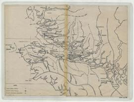
Item is a base map with added notations showing territories of South Kwakiutl tribes; former and present villages; and non-Indian settlements. Includes legend. All typed names of tribes and villages have been crossed through with pencil.
Item appears to be a working copy or preliminary draft of item #40. Sheets originally taped together.
Encapsulated. Base map: Southern Kwakiutl base map, Duff-CM-14.
Southern Kwakiutl villages and tribes
Part of Wilson Duff fonds
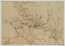
Item is a base map with ms. additions showing territories and names of South Kwakiutl tribes, names and locations of former and current villages, and non-Indian settlements. Includes legend. Marked "W. Duff 1966." Encapsulated.
Base map: Southern Kwakiutl base map, Duff-CM-14.
Part of Wilson Duff fonds
Item consists of detail map of Lowe Inlet, located on the peninsula between Chatham Sound and Douglas Channel, and map of Portland Inlet area, from Port Simpson to Greenville. Notation "Edward Gamble (Tsibasa) 1939." In English and Tsimshian. Detail of areas shown in Duff-CM-69.
Part of Wilson Duff fonds
Item is a map that shows Haida, Tsimshian, Bella Coola, Kwakiutl, and Coast Salish territorial boundaries. Correction made in northern Tsimshian boundary.
Part of Wilson Duff fonds
Item is a map that shows Tsimshian territory and sites. Copy of Duff-CM-69.
Part of Wilson Duff fonds
Item is a map that shows territories and numbered sites at Kispiox. Notation in upper corner reads "Jonathan Johnson, Kispiox, July 7, 1965 (see notebook and tape)." Encapsulated. In English and Tsimshian. A recorded interview with Johnson is available in Duff's sound reel tapes. Numbers added correspond to "Extracts from Notebook" sheets found in Duff's textual records.
Part of Wilson Duff fonds
Item is a copied map that shows territorial boundaries of the Kitwancool, territories of the Wolf and Frog clans, villages, and numbered sites. Inset: Location map. No legend provided for numbered sites. Based on "Territories of the Kitwancool" map included in Histories, Territories, and Laws of the Kitwancool, found in Duff's textual records, box 2, file 8. Mended with document repair tape in 1984. Encapsulated.
Part of Wilson Duff fonds
Item is a published map with ms. additions. Notations consist of pencil lines drawn through Sechelt provincial park and from Vancouver to Valdes Island. Base map : Sheet 92 G/SW : Vancouver / produced by Surveys and Mapping Branch, Lands and Forests, Victoria, 1959-1960. Torn, perforated and faded.
Part of Wilson Duff fonds
Item is a published map with ms. additions. Notations consist of lines and affixed labels identifying location and boundaries of Nahkwockto and Kwawkewlth territories. Marked "Map 1." Typed labels affixed with tape. Encapsulated. Base map: 92L : Alert Bay, British Columbia. -- 1st ed. / produced by the Army Survey Establishment, R.C.E., Department of Mines and Technical Surveys, Ottawa, 1965.
Part of Wilson Duff fonds
Item is a published map with ms. additions. Notations show location and boundaries of Qwawshelah and Nahkwockto territories; numbered labelled sites, including burial grounds. Includes some site acreage. Marked "Map 2" and "N. Nahkwockto." Typed labels affixed with tape. Encapsulated. Base map: 92 M : Rivers Inlet, British Columbia. -- 1st ed. / compiled and printed by Surveys and Mapping Branch, Department of Mines and Technical Surveys, Ottawa, 1964.
Part of Wilson Duff fonds
Item is a published map with ms. annotations. Notations include outlining and shading of Port Progress and numbered labels showing the location of Nahkwockto territory. Includes some indications of acreage. Marked "Map 3." Line drawn through Queen Charlotte Strait. Typed labels affixed with tape Encapsulated. Base map: 92 L/14 West : Port Progress, British Columbia / produced by the Army Survey Establishment, R.C.E., Ottawa, 1959.
Territory, reserves and village sites of
Part of Wilson Duff fonds
Item is a published map with ms. additions. Notations consist of attached typed labels showing village sites of Kwawkewlth territory, and some acreage. Marked "Map 4." Encapsulated. Base map: Sheet 92 L/11 West Port McNeill, Rupert District, British Columbia. -- 2nd ed. / published by the Army Survey Establishment, Ottawa, 1958.
Territory and reserves, and village sites of Kwawkewlth
Part of Wilson Duff fonds
Item is a published map with ms. additions. Notations consist of attached typed labels showing village sites, reserve numbers and acreage. Marked "Map 5." Encapsulated. Base map: Sheet 92 L/11 East : Port McNeill, British Columbia. -- 2nd ASE ed. / published by the Army Survey Establishment, R.C.E., Ottawa, 1958.
Part of Wilson Duff fonds
Item is a published map with ms. notations marking Saanich villages around Victoria. Perforated. Base map: Sheets 92 B/NW and B/SW (parts of) : Victoria, British Columbia. -- 1st status ed. / compiled and produced by Surveys and Mapping Branch, Lands and Forests, Victoria, 1958.