- 29-6-B-44-l
- Part
Part of Wilson Duff fonds
43 results with digital objects Show results with digital objects
Part of Wilson Duff fonds
Part of Wilson Duff fonds
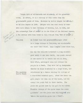
Text of Kitwancool sign by Peter Allik Petersenn
Part of Wilson Duff fonds
Part of Wilson Duff fonds
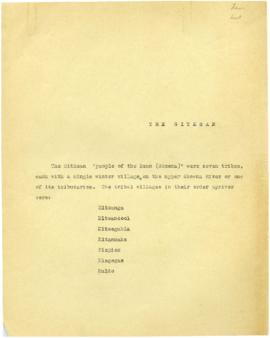
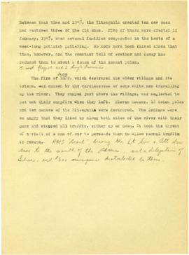
File consists of slides including: Kitwancool, Kitselas, Kitwanga, Kispiox, b&w slides of Kitsegukla, Gitksan grave markers.
Part of Wilson Duff fonds
File consists of slides including: exhibits at Museum of Natural History, exhibits at Museum of History and Technology, July 1970, trip to Hazelton, Rupert, and other locations. Images include Kitwancool, Skeena and Kitwanga poles and Kispiox totems.
Part of Wilson Duff fonds
File consists of slides including: beach views, dances at Kitsilano showboat dances, Aiyansh, Kispiox, Kitwancool, Kitwanga, Ksan, Kits canoe races.
Part of Wilson Duff fonds
Maps created, acquired, and used by Duff in his research and teaching activities. The materials show geographical features; location and boundaries of territories and villages of Northwest coast native people; reserves; language families and distribution, influences, and historical features. Included are ms. maps; and copied, traced, outline and published maps, most with added ms. notations.
The Base maps sub-series consists of topographic maps produced as bases for the creation of other maps to show the locations and territorial boundaries of native people within British Columbia. Maps include ms. notations by Duff.
The Territory maps sub-series consists of ms. maps; and base, outline, copied and photocopied maps with ms. notations. Items show location and boundaries of native territories in British Columbia and the United States. Includes maps showing extent and detail of Tsimshian territory; Kispiox sites; Kitwancool territory and sites; South Kwakiutl territory, villages and tribes. Notations identify some place names and villages.
The Reserve maps sub-series consist of copied and published maps with ms. notations showing the location and extent of various reserves. Some acreage is also included.
The Miscellaneous Maps sub-series consists of published, copied and outline maps showing language families in North America, influences on British Columbia native people, historical distribution of native people in B.C., and Vancouver Island in the 19th century.
Part of Wilson Duff fonds
Item is a copied map that shows Kitwancool territories and villages, rivers and lakes referred to in "Territories of the Kitwancool" chapter in Histories, Territories, and Laws of the Kitwancool. Title taken from duplicate found in Histories. Encapsulated.
Part of Wilson Duff fonds
Item is a copied map that shows places, rivers and lakes of Kitwancool territory referred to in "History of the wars with the Tse-tsaut: How the village of Git-an-yow became Kitwancool" chapter in Histories, Territories, and Laws of the Kitwancool. Encapsulated.
Part of Wilson Duff fonds
Item is a copied map that shows territorial boundaries of the Kitwancool, territories of the Wolf and Frog clans, villages, and numbered sites. Inset: Location map. No legend provided for numbered sites. Based on "Territories of the Kitwancool" map included in Histories, Territories, and Laws of the Kitwancool, found in Duff's textual records, box 2, file 8. Mended with document repair tape in 1984. Encapsulated.
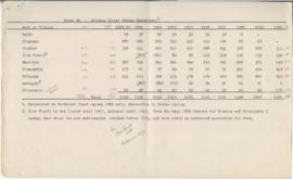
Page 4 - Gitxsan (Upper Skeena Tsimshian) population
Part of Wilson Duff fonds
Part of Wilson Duff fonds
Part of Wilson Duff fonds
Part of Wilson Duff fonds
Part of Wilson Duff fonds
Part of Wilson Duff fonds
Part of Wilson Duff fonds
Part of Wilson Duff fonds
Part of Wilson Duff fonds
Part of Wilson Duff fonds