Histories, territorial laws of the Kitwancool
- 29-3-02
- Dossiê
- 1959
Parte de Wilson Duff fonds
48 resultados com objetos digitais Mostrar resultados com objetos digitais
Histories, territorial laws of the Kitwancool
Parte de Wilson Duff fonds
Kitwancool poles- correspondence MoA/RBCM
Parte de Marjorie Halpin (MOA Curator) fonds
Anthropology 301 Gitksan - Kitwancool (301-8)
Parte de Wilson Duff fonds
Anthropology 301 Kitwancool (301-1-9)
Parte de Wilson Duff fonds
Parte de Wilson Duff fonds
Ans'pa yaxw (Kispiox) & Gitsegukla
Parte de Anthony Carter fonds
File consists of images of the Skeena River valley area in British Columbia, near Hazelton. Subjects include people, totem poles, scenery, and the the villages of Gitsegukla and Kitwancool.
Sem título
Parte de Minn Sjolseth fonds
Series consists of records (primarily photographic slides) documenting Minn Sjolseth's travels with her husband Anthony Carter to visit events and communities at locations including Haida Gwaii, Ketchikan, Kitwancool, Kingcome Inlet, Kispiox, Gitsegukla, Kitwanga and Skidegate among others. The contents of the series reflect First Nations cultures in British Columbia throughout the 1960s and 1970s, including Haida, Nuu-Chah-Nulth, Skwxwú7mesh, Nisga'a, Kwakwaka'wakw. The photographs document potlatches, totem poles, villages, landscapes, as well as portraits of individuals. The series also contains files with a small number of photographs documenting Sjolseth's paintings on these subjects, as well as Sjolseth at work on her art on location in these communities and locations.
Parte de Wilson Duff fonds
Maps created, acquired, and used by Duff in his research and teaching activities. The materials show geographical features; location and boundaries of territories and villages of Northwest coast native people; reserves; language families and distribution, influences, and historical features. Included are ms. maps; and copied, traced, outline and published maps, most with added ms. notations.
The Base maps sub-series consists of topographic maps produced as bases for the creation of other maps to show the locations and territorial boundaries of native people within British Columbia. Maps include ms. notations by Duff.
The Territory maps sub-series consists of ms. maps; and base, outline, copied and photocopied maps with ms. notations. Items show location and boundaries of native territories in British Columbia and the United States. Includes maps showing extent and detail of Tsimshian territory; Kispiox sites; Kitwancool territory and sites; South Kwakiutl territory, villages and tribes. Notations identify some place names and villages.
The Reserve maps sub-series consist of copied and published maps with ms. notations showing the location and extent of various reserves. Some acreage is also included.
The Miscellaneous Maps sub-series consists of published, copied and outline maps showing language families in North America, influences on British Columbia native people, historical distribution of native people in B.C., and Vancouver Island in the 19th century.
Parte de Wilson Duff fonds
File consists of slides including: exhibits at Museum of Natural History, exhibits at Museum of History and Technology, July 1970, trip to Hazelton, Rupert, and other locations. Images include Kitwancool, Skeena and Kitwanga poles and Kispiox totems.
Anthropology 301 Tsimshian 1)Kitwancool 2)Kitwancool 3)Alaska totems (week 5)
Parte de Wilson Duff fonds
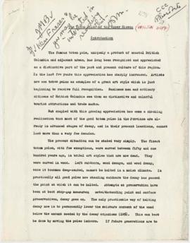
![[Histories, Territories and Laws of the Kitwancool]](/uploads/r/null/1/0/6/1061c9eb330200732e4fbd1d0428c3eed32efa8baf2dfb1fb5f2d5c86f17c015/WD46_08reduced_142.jpg)
[Histories, Territories and Laws of the Kitwancool]
Parte de Wilson Duff fonds
Parte de Wilson Duff fonds
Parte de Wilson Duff fonds
Text of Kitwancool sign by Peter Allik Petersenn
Parte de Wilson Duff fonds
Parte de Wilson Duff fonds
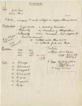
Item is a copied map that shows Kitwancool territories and villages, rivers and lakes referred to in "Territories of the Kitwancool" chapter in Histories, Territories, and Laws of the Kitwancool. Title taken from duplicate found in Histories. Encapsulated.
The fonds consists of a file titled Tsimshian Totem Poles and contains 38 black and white photographs of Kitwancool totem poles.
Sem título
Totem Poles of the Upper Skeena
Parte de Wilson Duff fonds
The War History of the Grizzly Bear People of the Kitselas People as Told by Chief Neas D. Hok
Parte de Wilson Duff fonds
Parte de Wilson Duff fonds
Parte de Wilson Duff fonds
Item is a copied map that shows places, rivers and lakes of Kitwancool territory referred to in "History of the wars with the Tse-tsaut: How the village of Git-an-yow became Kitwancool" chapter in Histories, Territories, and Laws of the Kitwancool. Encapsulated.