Área de título y declaración de responsabilidad
Título apropiado
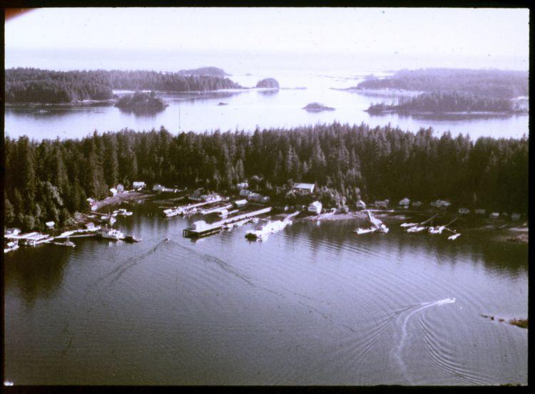
Kyuquot from the air
Tipo general de material
- Graphic material
Título paralelo
Otra información de título
Título declaración de responsabilidad
Título notas
- Source of title proper: Title based on a filmstrip description inventory list included in the collection.
Nivel de descripción
Item
Código de referencia
Declaración de edición
Declaración de responsabilidad de edición
Mención de la escala (cartográfica)
Mención de proyección (cartográfica)
Mención de coordenadas (cartográfica)
Mención de la escala (arquitectónica)
Jurisdicción de emisión y denominación (filatélico)
Área de fechas de creación
Fecha(s)
-
1975 or 1976 (Criação)
Área de descripción física
Descripción física
1 photograph : 35 mm color negative
Área de series editoriales
Título apropiado de las series del editor
Títulos paralelos de serie editorial
Otra información de título de las series editoriales
Declaración de responsabilidad relativa a las series editoriales
Numeración dentro de la serie editorial
Nota en las series editoriales
Área de descripción del archivo
Nombre del productor
Historial de custodia
Alcance y contenido
An image of an aerial view of the Kyuquot village. According to the documentation included with the filmstrip, the description of the image states "Kyuquot from the air. You can see Walter's Island and out into the Pacific Ocean. The next Island to the right is Aktis Island, the ancestral home of the Kyuquot Band. In the early 1800's the Kyuquot Band was the largest on the West Coast of Vancouver Island. However one night in 1855 the Clayoquots, enemies to the Kyoquots, surprised the Kyuquot Village on Atkis Isl., cut off the heads of the Kyuquot warriers, took the women as slaves, and set fire to the village. Most of the village was destroyed during this, the last tribal war fought on the West Coast of Vancouver Island. A few years ago most of the Kyuquot Band left Atkis Island and moved into Walter's Cove."