- 29-13-016-d
- Part
Part of Wilson Duff fonds
48 results with digital objects Show results with digital objects
Part of Wilson Duff fonds
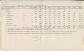
Page 4 - Gitxsan (Upper Skeena Tsimshian) population
Part of Wilson Duff fonds
Part of Wilson Duff fonds
Item is a copied map that shows territorial boundaries of the Kitwancool, territories of the Wolf and Frog clans, villages, and numbered sites. Inset: Location map. No legend provided for numbered sites. Based on "Territories of the Kitwancool" map included in Histories, Territories, and Laws of the Kitwancool, found in Duff's textual records, box 2, file 8. Mended with document repair tape in 1984. Encapsulated.
Part of Wilson Duff fonds
Item is a copied map that shows places, rivers and lakes of Kitwancool territory referred to in "History of the wars with the Tse-tsaut: How the village of Git-an-yow became Kitwancool" chapter in Histories, Territories, and Laws of the Kitwancool. Encapsulated.
Part of Wilson Duff fonds
Item is a copied map that shows Kitwancool territories and villages, rivers and lakes referred to in "Territories of the Kitwancool" chapter in Histories, Territories, and Laws of the Kitwancool. Title taken from duplicate found in Histories. Encapsulated.
Part of Wilson Duff fonds
Maps created, acquired, and used by Duff in his research and teaching activities. The materials show geographical features; location and boundaries of territories and villages of Northwest coast native people; reserves; language families and distribution, influences, and historical features. Included are ms. maps; and copied, traced, outline and published maps, most with added ms. notations.
The Base maps sub-series consists of topographic maps produced as bases for the creation of other maps to show the locations and territorial boundaries of native people within British Columbia. Maps include ms. notations by Duff.
The Territory maps sub-series consists of ms. maps; and base, outline, copied and photocopied maps with ms. notations. Items show location and boundaries of native territories in British Columbia and the United States. Includes maps showing extent and detail of Tsimshian territory; Kispiox sites; Kitwancool territory and sites; South Kwakiutl territory, villages and tribes. Notations identify some place names and villages.
The Reserve maps sub-series consist of copied and published maps with ms. notations showing the location and extent of various reserves. Some acreage is also included.
The Miscellaneous Maps sub-series consists of published, copied and outline maps showing language families in North America, influences on British Columbia native people, historical distribution of native people in B.C., and Vancouver Island in the 19th century.
The Wilson Duff papers consist of textual records, photographs, negatives, slides, maps, audio recordings, compact disks and one video tape that relate to Duff's activities, correspondences, and publications as one of the foremost researchers in Northwest coast Indian history, culture and traditions. Also included in the fonds are records relating to Duff’s work as an Anthropology professor at the University of British Columbia, his advisory and curatorial consultancy work, committee membership and the exhibit Images: Stone: B.C.
Records in the Wilson Duff fonds have been organized into the following seventeen series:
Series 1: Wilson Duff’s student papers (1949-1950)
Series 2: Correspondence (195?-1975)
Series 3: Published and unpublished articles (195?-1972)
Series 4: Site visits (195-)
Series 5: Northwest Coast research (195?-197?)
Series 6: Teaching materials (1965-1976)
Series 7: Committee and consultancy records (1966-1976)
Series 8: Personal records (1965-1976)
Series 9: Photographic records (195?-1976)
Series 10: Maps (1955-1976)
Series 11: Images: Stone: B.C. (1975-1977)
Series 12: Research notes and materials (196?-1976)
Series 13: Tsimshian files (1915-1976, predominant 1957-1971)
Series 14: Recordings (1962-1976)
Series 15: Creative writing (195?  - 197?)
Series 16: Posthumous writings on Duff (197? – 199?)
Series 17: Ephemera (195? – 197?)
Wilson Duff
Part of Anthony Carter fonds
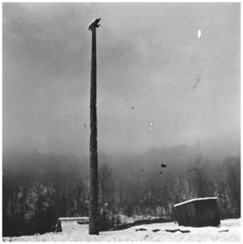
Image of a bear pole in Kitwancool, BC. This pole is pictured on page 119 of Carter's book Abundant Rivers.
Anthony Carter
Ans'pa yaxw (Kispiox) & Gitsegukla
Part of Anthony Carter fonds
File consists of images of the Skeena River valley area in British Columbia, near Hazelton. Subjects include people, totem poles, scenery, and the the villages of Gitsegukla and Kitwancool.
Anthony Carter
Ketchikan and Kitwancool Totems and Views
Part of Minn Sjolseth fonds
File consists of slides depicting totems and views labeled as in Kispiox, Kitwancool, Ketchikan, Haida, Kitseguckla, Skedans, and Kingcome. File also consists of slides documenting two of Minn Sjolseth's paintings entitled "En av de Siste" (sp?) and "Peace."
Part of Minn Sjolseth fonds
File consists of slides labeled "Andy," "Mr and Mrs Williams, Friendly Cove, Nootka," "Anthony Island Queen Charlotte Island 1967," "Minn Sketching at Yan QCI, Haida," "Kitwancool 1969," "Kasper," "Mary Ann 1967 Squamish," and "Kingcome."
Part of Minn Sjolseth fonds
Series consists of records (primarily photographic slides) documenting Minn Sjolseth's travels with her husband Anthony Carter to visit events and communities at locations including Haida Gwaii, Ketchikan, Kitwancool, Kingcome Inlet, Kispiox, Gitsegukla, Kitwanga and Skidegate among others. The contents of the series reflect First Nations cultures in British Columbia throughout the 1960s and 1970s, including Haida, Nuu-Chah-Nulth, Skwxwú7mesh, Nisga'a, Kwakwaka'wakw. The photographs document potlatches, totem poles, villages, landscapes, as well as portraits of individuals. The series also contains files with a small number of photographs documenting Sjolseth's paintings on these subjects, as well as Sjolseth at work on her art on location in these communities and locations.
The fonds consists of a file titled Tsimshian Totem Poles and contains 38 black and white photographs of Kitwancool totem poles.
Charles E. Borden
Part of MOA General Media collection
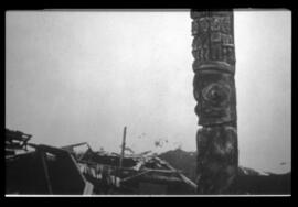
Totem pole standing in situ at Kitwancool. It was later removed and taken to the University of British Columbia. It currently stands in the Great Hall at the Museum of Anthropology.
Early MOA activities and curatorial research
Part of MOA General Media collection
Subseries consists mainly of photographs collected by MOA for curatorial research, as well as some photographs documenting MOA activities and/or people. Photographs in this subseries were collected in 1976 or earlier. Subject matter of the photographs includes Northwest Coast material culture, people, and geography; MOA history; MOA events; UBC Totem Park; and, a smaller number of non-Northwest Coast cultures.
See attached pdf document for photograph list.
Kitwancool poles- correspondence MoA/RBCM
Sub-series consists of textual records including correspondence regarding and general research notes on totem poles, and specific research on the poles of Stanley Park and the artisans who worked on them. Records also include biographies on the artisans who carved the museum totem poles and correspondence and the agreement between the Museum of Anthropology and the Royal British Columbia Museum to remove totem poles from Kitwancool in 1958. Sub-series also contains slides of totem poles, three video tapes, one photograph and one cassette tape.
MacDonald #27 Kitwancool not in TPG yaxyaq
Kitwancool yaxyaq MacDonald #22 not in TPG