![Mrs. Wilson ([Nuu-chah-nulth] basket weaver) and Able John, Gold River](/uploads/r/null/d/3/2/d326768ef9a62f7332f2dae816ad683f50719618c4fe194af5f70d3c88565ee4/a038172c_142.jpg)
Mrs. Wilson ([Nuu-chah-nulth] basket weaver) and Able John, Gold River
- 25-03-11-a038172
- Item
- August 1972
Part of Anthony Carter fonds
Portrait of Able John, who was born at Ehahsitaht but moved to Gold River.
Anthony Carter
Mrs. Wilson ([Nuu-chah-nulth] basket weaver) and Able John, Gold River
Part of Anthony Carter fonds
Portrait of Able John, who was born at Ehahsitaht but moved to Gold River.
Anthony Carter
![Mrs. Wilson ([Nuu-chah-nulth] basket weaver), Gold River](/uploads/r/null/0/4/1/041fbf5abc0b8b26b53c6d6f38e6c77400ff96da910362e2012093e8810768b0/a038173c_142.jpg)
Mrs. Wilson ([Nuu-chah-nulth] basket weaver), Gold River
Part of Anthony Carter fonds
Close-up image of Mrs. Wilson weaving a basket. A similar image is printed on page 112 of Carter's book "From History's Locker."
Anthony Carter
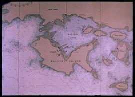
Nautical chart of Walters Island
An image showing a sea map of Walters Island, a small blue circle at the top center indicates the approximate location of the Kyuquot village. According to the documentation included with the filmstrip, the description of the image states "Kyuquot as shown on chart (A chart is a sea-map used by fishermen and boaters.) Compare the chart and the map."
Northwest Coast Indigenous peoples
Part of Reverend Thomas Crosby fonds
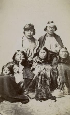
Image is a posed group portrait of two men, three women, and a girl seated together on an elaborate tile floor. All people pictured are wearing blankets. In the center front of the people is a fur and a small woven basket. Photographer information printed on verso with the inscription "Mrs. R. Maynard, PHOTOGRAPHIC ARTIST, AND DEALER IN All KINDS OF PHOTOGRAPHIC MATERIALS. Stereoscopic and Large Views of British Columbia and Vancouver Island for sale. Corner of Douglas and Johnson Sts, VICTORIA, B. C."
![Nuu-chah-nulth], Yuquot (Friendly Cove)](/uploads/r/null/e/8/0/e809bd0629d0ada1dd5d5511321bbee8c940ba469ebc52717e41e815f4ccf91e/a038120c_142.jpg)
Nuu-chah-nulth], Yuquot (Friendly Cove)
Part of Anthony Carter fonds
Image of a rocky shoreline, with an unidentified person standing on top o of the rocks in the distance.
Anthony Carter
![Nuu-chah-nulth], Yuquot (Friendly Cove)](/uploads/r/null/5/f/6/5f61fa3026f2dd6f247a7f34742127635bdf1d2693ca4cd8174d5ec404ef80f4/a038121c_142.jpg)
Nuu-chah-nulth], Yuquot (Friendly Cove)
Part of Anthony Carter fonds
Image of driftwood, with a small inlet and mountains behind it.
Anthony Carter
![Nuu-chah-nulth], Yuquot (Friendly Cove)](/uploads/r/null/d/1/8/d18ef416ad4c25b1e03abc9dae7c396220ebc54e18509b7903b8ddc2ccb0edd6/a038126c_142.jpg)
Nuu-chah-nulth], Yuquot (Friendly Cove)
Part of Anthony Carter fonds
Image of a rocky beach, near Nootka, BC.
Anthony Carter
![Nuu-chah-nulth], Yuquot (Friendly Cove)](/uploads/r/null/1/f/3/1f3ca2e77b08cb02f4b40e1524c9e155ffa0b959bc37085f8364439c0a8c880e/a038127c_142.jpg)
Nuu-chah-nulth], Yuquot (Friendly Cove)
Part of Anthony Carter fonds
Image of a rocky beach, near Nootka, BC.
Anthony Carter
![Nuu-chah-nulth], Yuquot (Friendly Cove)](/uploads/r/null/0/6/e/06e5794d02f112c1926eae62327c73906888f212a5d606202209465911f456f5/a038128c_142.jpg)
Nuu-chah-nulth], Yuquot (Friendly Cove)
Part of Anthony Carter fonds
Image of a floatplane on the water near a beach, with a small island nearby and mountains in the distance.
Anthony Carter
![Nuu-chah-nulth], Yuquot (Friendly Cove)](/uploads/r/null/9/7/d/97df9da9ab2e3f88c41cc5e0cdb0ac4f27f780ef7fe884fa7f4f0f83b785609a/a038114c_142.jpg)
Nuu-chah-nulth], Yuquot (Friendly Cove)
Part of Anthony Carter fonds
Image of a beach and inlet, with mountains and islands in the distance, near Nootka on Vancouver Island.
Anthony Carter
![Nuu-chah-nulth], Yuquot (Friendly Cove)](/uploads/r/null/9/c/a/9ca6c8a858b7da680a4a1b5a685438f51d37768643deb39d2cceb6814dec56e3/a038116c_142.jpg)
Nuu-chah-nulth], Yuquot (Friendly Cove)
Part of Anthony Carter fonds
Image of a village located on a small inlet, surrounded by forest.
Anthony Carter
![Nuu-chah-nulth], Yuquot (Friendly Cove)](/uploads/r/null/5/6/b/56b4b5745d0a4571c2b57bbc624543175b97a447953b1d908de27cd4f6f6034f/a038118c_142.jpg)
Nuu-chah-nulth], Yuquot (Friendly Cove)
Part of Anthony Carter fonds
Image of water crashing up onto a rocky beach.
Anthony Carter
![Nuu-chah-nulth], Yuquot (Friendly Cove)](/uploads/r/null/a/0/0/a006564c5e86218078137af3343a3498a94922a0951f25b32af28a42e486b18c/a038119c_142.jpg)
Nuu-chah-nulth], Yuquot (Friendly Cove)
Part of Anthony Carter fonds
Image of a sea anemone.
Anthony Carter
![Nuu-chah-nulth], Yuquot (Friendly Cove)](/uploads/r/null/e/d/f/edfbe3ba44396f4dc020099388cf88b3682453ebe15156db42bfca20108f9a73/a038122c_142.jpg)
Nuu-chah-nulth], Yuquot (Friendly Cove)
Part of Anthony Carter fonds
Image of artist Minn Sjolseth, Carter's wife, sitting on the back of a fishing vessel. Mountains are in the background. Carter provides more information about Sjolseth on page 133 of his book "From History's Locker."
Anthony Carter
![Nuu-chah-nulth], Yuquot (Friendly Cove)](/uploads/r/null/b/5/4/b54d3c19f6a71977f451f65af16007e331499446f831b2790451a1a618596943/a038124c_142.jpg)
Nuu-chah-nulth], Yuquot (Friendly Cove)
Part of Anthony Carter fonds
Image looking out from grassy hill onto water and small islands near Nootka BC.
Anthony Carter
![Nuu-chah-nulth], Yuquot (Friendly Cove)](/uploads/r/null/b/a/7/ba77e7e5c16d341a5d05475d7455c7c813cfc2bb997cd36ea49e5151c4714509/a038115c_142.jpg)
Nuu-chah-nulth], Yuquot (Friendly Cove)
Part of Anthony Carter fonds
Image of a beach and inlet, with mountains in the distance, near Nootka on Vancouver Island.
Anthony Carter
![Nuu-chah-nulth], Yuquot (Friendly Cove)](/uploads/r/null/0/0/8/0089534ff103664b5bf7f4b10f56ce267f1a22c9c637b15422e63868e1f4a41a/a038117c_142.jpg)
Nuu-chah-nulth], Yuquot (Friendly Cove)
Part of Anthony Carter fonds
Image of a beach and inlet, with mountains in the distance, near Nootka on Vancouver Island.
Anthony Carter
![Nuu-chah-nulth], Yuquot (Friendly Cove)](/uploads/r/null/c/b/c/cbceaa80d0b7b7ccd7d84c45f49d7f7049ad340f370db1be997b1b861ab978d6/a038123c_142.jpg)
Nuu-chah-nulth], Yuquot (Friendly Cove)
Part of Anthony Carter fonds
Image of the water and mountains near Nootka, BC.
Anthony Carter
![Nuu-chah-nulth], Yuquot (Friendly Cove)](/uploads/r/null/2/b/b/2bb40b24d2a2a59560a3079a0491f9198eda4a07fb4fdac058ab9b45320543fa/a038125c_142.jpg)
Nuu-chah-nulth], Yuquot (Friendly Cove)
Part of Anthony Carter fonds
Image of a beach covered in logs and driftwood.
Anthony Carter
![Nuu-chah-nulth], Yuquot (Friendly Cove)](/uploads/r/null/c/3/b/c3b10720acee7320ab2283ea2677a9d20cd96d82e8e2602455897b10ba58ccaa/a038129c_142.jpg)
Nuu-chah-nulth], Yuquot (Friendly Cove)
Part of Anthony Carter fonds
Image of small islands near the shore.
Anthony Carter