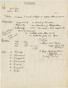
File consists of images of the Skeena River valley area in British Columbia, near Hazelton. Subjects include people, totem poles, scenery, and the the villages of Gitsegukla and Kitwancool.
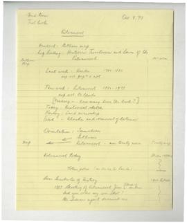
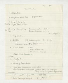
File contains historical photographs of Gitxsan villages, with a specific focus on totem poles and various buildings in the villages. There are also some images of the Gitxsan people in regalia. The textual records contain information to some of the photographs, listing the photograph's title and the museum and/or archive it originated from.
File consists of photographic prints depicting Gitanyow cultural objects from other institutions. Many of the prints are annotated with handwritten, stamped, or typed information about the contents of the images or their original repositories. The contents of this file were used to create object labels for MOA Object ID A50019 in MOA's Great Hall.
File consists of slides including: exhibits at Museum of Natural History, exhibits at Museum of History and Technology, July 1970, trip to Hazelton, Rupert, and other locations. Images include Kitwancool, Skeena and Kitwanga poles and Kispiox totems.
Item is a copied map that shows Kitwancool territories and villages, rivers and lakes referred to in "Territories of the Kitwancool" chapter in Histories, Territories, and Laws of the Kitwancool. Title taken from duplicate found in Histories. Encapsulated.
Item is a copied map that shows places, rivers and lakes of Kitwancool territory referred to in "History of the wars with the Tse-tsaut: How the village of Git-an-yow became Kitwancool" chapter in Histories, Territories, and Laws of the Kitwancool. Encapsulated.
Item is a copied map that shows territorial boundaries of the Kitwancool, territories of the Wolf and Frog clans, villages, and numbered sites. Inset: Location map. No legend provided for numbered sites. Based on "Territories of the Kitwancool" map included in Histories, Territories, and Laws of the Kitwancool, found in Duff's textual records, box 2, file 8. Mended with document repair tape in 1984. Encapsulated.
![[Histories, Territories and Laws of the Kitwancool]](/uploads/r/null/1/0/6/1061c9eb330200732e4fbd1d0428c3eed32efa8baf2dfb1fb5f2d5c86f17c015/WD46_08reduced_142.jpg)