- 119-7-F-2
- Bestanddeel
- 2007
Part of Director's fonds
13183 results with digital objects Show results with digital objects
Part of Director's fonds
Vancouver Zoo, UBC Dept. of Zoology
Vancouver Virtual Museum [VVM]
Part of Skooker Broome fonds
Vancouver Virtual Museum – Vancouver Foundation
Part of Skooker Broome fonds
Part of Skooker Broome fonds
Subseries consists of records relating to Skooker Broom’s responsibilities as the Museum of Anthropology liaison and coordinator for the development of a Vancouver Virtual Museum consortium and for the creation and development of proposals for a virtual museum. Records include correspondence, memoranda, reports, agendas, business cards, guidelines, confidential reports, confidential and proprietary documents, Vancouver Virtual Museum Society’s Act, minutes, grant applications (copies), expense lists, estimates, draft letters, grant notifications, agreement guides, drafts & final proposals, terms of projects, licensing agreements booklet, budgets, agreements, corporate reports, and consultation reports.
Vancouver Symphony Orchestra co-performance
Part of Wilson Duff fonds
Item is a published topographic map with ms. additions showing Vancouver area reserves. Notation on verso: "Pete Stabie, 1577717, Anthro 301." Base map: 92G : Vancouver, British Columbia. -- 1st ed. / produced by Surveys and Mapping Branch, Department of Mines and Technical Surveys, Ottawa, 1959.
File consists of a photograph taken of a Quileute photographs in the Vancouver Public Library collections.
Vancouver Partnership, Tourism & the Arts seminar
Vancouver Museum loan agreement and correspondence [restricted]
Part of Carol Mayer fonds
Vancouver Museum Collection records
Part of Jennifer Kramer fonds
File consists of catalogue records and related correspondence and printouts of digital colour and b&w photographs.
Vancouver Museum - image recovery process
File contains copies of correspondence between McLennan and the Vancouver Museum regarding the image recovery project.
File consists of colour photographs of Northwest Coast artifacts including masks, spoons, boxes, hats, and sculptures housed at the Museum of Vancouver.
File contains images of bentwood boxes and cedar hats housed at the Vancouver Museum (now the Museum of Vancouver). The textual records contained in this file are copies of catalogue records.
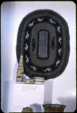
Vancouver Island rag rug and other contemporary examples
Part of MOA General Media collection
Display from the exhibit "North American Indian Basketry and Technology." Shows several examples of applications of basketry technology to new items including a rug, a bottle sleeve, and other items. Many items for this exhibit were borrowed from the University of Washington to supplement the museum's collection.
Vancouver Island and area territories
Part of Wilson Duff fonds
Items are published maps with ms. additions. Notations show the territories of the South Kwakiutl, Nootka and Coast Salish tribal groups; and some place names. Arrows drawn may represent the southward migration of the Comox, mentioned in Duff's lecture notes (box 11, file 3; box 8, file 32); and arrows and dates may indicate the annual movements for reef netting described in his lecture notes on the Coast Salish (box 7, file 25 and box 8, file 41). Notations are possibly in Duff's hand. Both sheets have been cut, possibly for presentation purposes. Encapsulated. Base maps cannot be identified.
Part of Wilson Duff fonds
Item is a map that shows location of South Kwakiutl, Coast Salish, and Nootka native people on Vancouver Island and within the surrounding area. May be in Duff's hand. Encapsulated.