Trickster Performance Hand-Out 1988
- 110-1-A-9
- Dossiê
- 1988
12948 resultados con objetos digitales Muestra los resultados con objetos digitales
Trickster Performance Hand-Out 1988
[Trickster - "A Rattling Under Glass"] [restricted]
Parte deDirector's fonds
Tribute to the Dead, 1912, Piegan, Montana
Parte deRoland Reed collection
Image of a Piegan Blackfeet memorial structure, with a man and woman next to it.
Parte deWilson Duff fonds
Parte deWilson Duff fonds
Item is a copied base map with ms. additions showing Tlingit, Haida, Pentlatch and Bella Coola territories in eighteenth-century British Columbia. Notations in Duff's hand. Encapsulated. Base map: British Columbia base map, Duff-CM-23.
Parte deDirector's fonds
Parte deEric Parker fonds
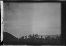
Item is a negative showing trees, mountains and the sky.
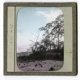
Trees and tori gate on hillside
Parte deJames Davidson collection
Item is a photograph of trees and a tori gate on a hillside. Reads, "SUN SET."
Parte deJames Davidson collection
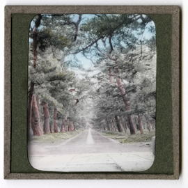
Item is a photograph of a tree-lined road.
![Treeline[?] of Nathula](/uploads/r/null/8/2/82520f7de1da29fe84e004d7ae8a2752f214f36b0bcdb3b98b59b5c213deceac/a033562c_142.jpg)
Parte deEric Parker fonds
Item is a photograph showing a house situated in a forest.
Parte deJames Davidson collection
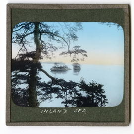
Item is a photograph of a tree in the foreground with sea and islands in background. Reads, "INLAND SEA."
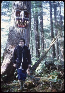
Photograph of an unidentified woman standing in the forest in front of a tree that has a face carved into it and painted. The tree is likely in or near Alert Bay, BC.
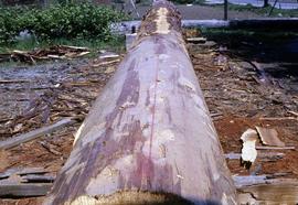
Tree with bark partially removed
Parte deVirginia Kehoe fonds
Image depicts a tree with the bark partially stripped.
![Tree trunks [Upper Mimika, New Guinea]](/uploads/r/null/f/b/4/fb467ba526a377ae66e9b30a434fc8dae7aec1fc60e167d9550b49264057162c/a032998c_142.jpg)
Tree trunks [Upper Mimika, New Guinea]
Parte deA.F.R. Wollaston fonds
Sin título
Parte deStanley E. Read fonds
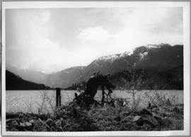
Image depicts an object that may be a bent tree trunk at the edge of a body of water. The foreground contains brush; mountains are visible in the distance.
![[Tree stumps with carvings and tools]](/uploads/r/null/5/0/7/507f43cd027d3c33892d91d185e4d887fdab9b28fa4bac0ee00c8a56cded688e/a036047c_142.jpg)
[Tree stumps with carvings and tools]
Parte deRonnie Tessler fonds
Image is of two tree stumps upon which two carvings are placed. Wood scraps, tape measure(?) and chisels are placed on top of one stump. Hand-adzes and chisels are visible in background of image.
![[Tree stumps with carvings and tools]](/uploads/r/null/0/9/4/094127e2796f57e2cc7610ddd9f1c4e8a511e943d3f67bd36effd61b985ba251/a036046c_142.jpg)
[Tree stumps with carvings and tools]
Parte deRonnie Tessler fonds
Image is of two tree stumps upon which two carvings are placed. Wood scraps, tape measure(?) and chisel are placed on top of one stump. An adze is visible in background of image.
![[Tree stumps with carvings and tools]](/uploads/r/null/a/4/c/a4c2c85ef543c663a2c37567bde91e5137f23571308e8e4c5658670b6f137e68/a036048c_142.jpg)
[Tree stumps with carvings and tools]
Parte deRonnie Tessler fonds
Image is of two tree stumps upon which two carvings are placed. Wood scraps, tape measure(?) and chisels are placed on top of one stump. Hand-adzes and chisels are visible in background of image.
![[Tree stumps with carvings and tools]](/uploads/r/null/7/4/b/74b72a37765cccf566453777118151d42675a85a8bef224f6cdc47dc668b7080/a036049c_142.jpg)
[Tree stumps with carvings and tools]
Parte deRonnie Tessler fonds
Image is of two tree stumps upon which two carvings are placed. Wood scraps, tape measure(?) and chisels are placed on top of one stump. Hand-adzes and chisels are visible in background of image.