Queen Charlotte Islands base map
- 29-10-A-04
- File
- 1965-1976
Part of Wilson Duff fonds
Map is marked "16 mile."
13494 results with digital objects Show results with digital objects
Queen Charlotte Islands base map
Part of Wilson Duff fonds
Map is marked "16 mile."
This file contains images of totem poles taken by Edward Malin and used in the Quatsino source book.
Quatsino Sound [standing on shore with paddle and boat]
Part of Ben Williams Leeson collection
Written on back of print: "Quatsino Sound."
Part of MOA General Media collection
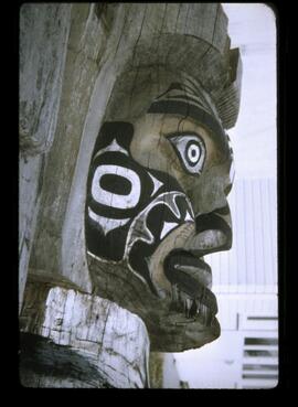
Detail of a house post from the Museum of Anthropology's collection.
Part of Wilson Duff fonds
QNR (Quileute Natural Resources) annual reports
Part of Wilson Duff fonds
Part of Wilson Duff fonds
Part of Wilson Duff fonds
Part of Gillian Darling Kovanic fonds
Images of the Queen Charlotte Islands
![Q CH IS 1951 [Queen Charlotte Islands]](/uploads/r/null/9/4/6/946d3a531a66ad314909e5292ebc6b3c25bade528100e1aa4eecb955931f5103/a039914c_142.jpg)
Q CH IS 1951 [Queen Charlotte Islands]
Part of Harry B. Hawthorn fonds
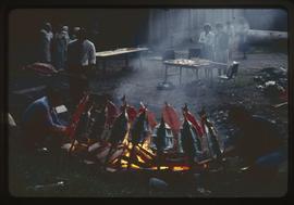
People observe as salmon are brought to be put on the fire
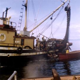
Putting fish over to go into hold
Photograph of a fishing boat named Cospak. In this image, the men are pulling up fish in a net to go into the hold of the ship. A stamp on the verso indicates that it was printed in 1957.
Mildred Laurie
Part of Wilson Duff fonds
Part of Elizabeth Johnson fonds
Purchase of village crafts from Columbia, South Africa
Purchase of Antique Chinese Hair Ornaments